
In May 1732, Charles Calvert, the fifth Lord Baltimore, agreed to a boundary settlement with the heirs of William Penn. The arrangement was supposed to resolve a dispute over Maryland, Pennsylvania, and the three counties along the Delaware River that had been going on for half a century. Unfortunately for Baltimore, the map attached to the agreement placed Cape Henlopen near what we now call Fenwick Island, roughly twenty miles south of the actual cape.
A misplaced coastal landmark may not sound like a particularly expensive mistake. But the location of Cape Henlopen was used to define a line running west across the Delmarva Peninsula, and moving the starting point south moved the boundary with it. The Delaware Heritage Commission’s history of the boundary estimates that the error cost Maryland about 800 square miles of land it claimed.
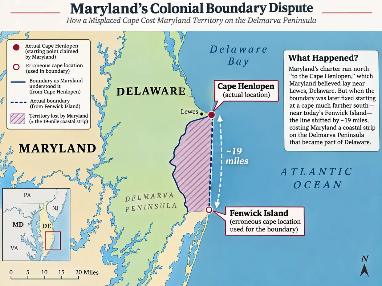
Worse, the map was based on the plan supplied by Baltimore’s own side. The Maryland State Archives’ description of the 1732 Senex map records that both parties brought maps to the negotiations, that Baltimore’s was accepted, and that John Senex engraved the map accompanying the agreement. Baltimore would later argue over the map and refuse to honor the settlement. The Penns took him to court.
This would be a good enough story if no one had made a better map. But Augustine Herrman had already published one in 1673.
The Map That Came First
Augustine Herrman was a surveyor and cartographer whose Virginia and Maryland as it is Planted and Inhabited remains an extraordinary record of the Chesapeake region. The engraving was published in London in 1673, although the title refers to the region as surveyed in 1670. Herrman’s work is not simply a sketch of the shoreline. It includes rivers, settlements, roads, county boundaries, Indigenous locations, and a rather impressive amount of geographical detail for its time.
Edward C. Papenfuse, writing about Maryland’s early cartography, notes that Herrman’s map correctly identified Cape Henlopen. The older maps by Nicolaes Visscher, however, placed the name on a different feature farther south. Senex’s agreement map perpetuated the southern location. This was not a problem that no one in the seventeenth or eighteenth century could have recognized. Competing cartographic evidence already existed.
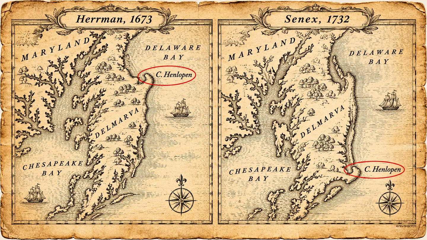
There is a complication worth preserving. Cape names moved around as European mariners, surveyors, and mapmakers recorded the coastline. The northern cape near present-day Lewes appeared under other names, including Cape Cornelius, while the feature near Fenwick Island could be called the false cape. The Senex map showed both Cape Cornelius and a Cape Hinlopen farther south. Saying that the cape was simply drawn in the wrong place compresses a more interesting problem: two different places were being associated with a name that a legal agreement needed to mean exactly one place. The Maryland State Archives records the two-cape problem directly.
The Maryland State Archives’ account of the litigation makes the omission explicit: Lord Baltimore never produced Herrman’s map in rebuttal. We should still be cautious about imagining Baltimore sitting at a desk with Herrman’s map on one side and Senex’s on the other, knowingly choosing the wrong one. The records establish that the better geography existed and was not introduced in the litigation; they do not tell us everything Baltimore or his negotiators had physically in front of them when they signed the agreement.
But an available geographical correction is one thing. An enforceable boundary agreement is quite another.
A Cold War Between Proprietors
Maryland’s trouble did not begin at Cape Henlopen. Its original charter described a northern boundary at the fortieth parallel. Pennsylvania’s later grant placed William Penn in territory that overlapped Maryland’s claimed northern reach, including land near Philadelphia. Pennsylvania was established in 1681, and Penn acquired the three Lower Counties in 1682. In effect, royal grants had produced two proprietorial claims that could not both be satisfied as originally understood.
The interests were hardly academic. A boundary determined which proprietor could grant land, collect rents, appoint officers, and exercise governmental authority. A settler whose land was claimed by both colonies might discover that the dispute was not merely over the color of a line on a map. There could be competing demands for taxes and competing assertions of jurisdiction. Surveying was one part of the problem; institutional authority was another.
The Penn and Calvert families fought over these claims for decades. Calling it a cold war is tempting, although the northern conflict eventually turned decidedly hot. In the 1730s, around the Susquehanna River, the overlapping claims produced raids, evictions, arrests, and armed confrontations in what became known as Cresap’s War, sometimes called the Conojocular War. Thomas Cresap, a Maryland partisan living in disputed territory, became one of its central figures. Maryland’s own archaeological records describe his raids and eventual capture after his blockhouse was attacked and burned.
Cresap’s fight was on the northern frontier, not at Cape Henlopen. These were geographically distinct disputes arising from the same incompatible colonial claims. That distinction matters because the disputed southern cape did not somehow cause the violence along the Susquehanna. It was part of a wider conflict in which maps, charters, and armed men were all being used to determine whose authority counted.
In 1737 the Crown intervened to stop the fighting; further royal orders in 1738 imposed temporary boundary arrangements. The proprietors were still left to resolve the underlying claims. The 1732 settlement, meanwhile, had already provided the legal foundation on which the eventual boundary could be forced into existence.
The Agreement Becomes the Geography
The agreement of May 10, 1732, did not just identify Cape Henlopen. It combined several pieces of geometry. From the named cape a line would run west to the midpoint of the peninsula. Another line would run north toward a circle surrounding New Castle. The boundary then had to accommodate that circle and proceed toward a line fixed fifteen miles south of Philadelphia.
The circular portion deserves a mention because it produced some of the strangest boundaries in the country. New Castle’s famous Twelve-Mile Circle is a circle defined by a distance from the town, not a conventional line of latitude or longitude. Even the colonial commissioners argued about whether the twelve miles described the radius or the circumference. The Delaware boundary history records that disagreement among the commissioners appointed to turn the 1732 agreement into surveyed lines.
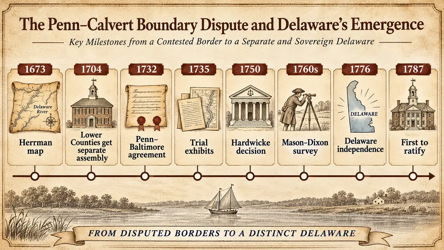
Baltimore subsequently resisted implementation. He disputed the geography and argued that the map attached to the agreement should not govern. The Penns wanted the agreement enforced. In 1750 Lord Hardwicke, sitting as Lord Chancellor, ruled that the settlement was binding. In effect, the courts treated the location agreed upon on the map as the contractual reference, whether or not it corresponded to the cape a surveyor would identify on the ground. The parties had reached an agreement, and Baltimore could not escape it merely because its consequences had become unattractive.
This is where the story stops being about the accuracy of a picture. The map had become part of an agreement, and the agreement supplied the authority to draw a line. Geographic evidence could establish that the actual cape was somewhere else, but that did not automatically undo the document the parties had signed. Once the courts upheld the bargain, surveying the agreed boundaries became an engineering problem.
Charles Mason and Jeremiah Dixon were engaged in 1763, and the surveying work continued through 1767. Their names now dominate the history of the Pennsylvania–Maryland boundary, but they did not invent the underlying property dispute or the 1732 settlement. Their task was to turn a legally defined boundary, and some rather difficult geometry, into lines and monuments on the ground. The Maryland State Archives’ Senex map record traces this sequence from the agreement through the court ruling to Mason and Dixon.
The northern line was another substantial concession. The Delaware Heritage Commission estimates that setting Maryland’s northern boundary fifteen miles south of Philadelphia, rather than at the fortieth parallel claimed under the charter, cost Maryland some 3,700 square miles of claimed territory. That is distinct from the approximately 800 square miles associated with the southern cape. We should not add the numbers together and blame the entire territorial settlement on one misplaced label. Some losses followed the negotiated compromise; one especially memorable part followed the geography of the map.
The State That Wasn’t Quite a Colony
All of this presents a small problem for the way Delaware tells its history. Delaware calls itself The First State. That is entirely correct if we are referring to the first state to ratify the United States Constitution, on December 7, 1787. But as an independent political entity, Delaware’s history is a little more complicated.
The territory was not newly settled in the eighteenth century. Swedish and Dutch settlements long preceded Penn, and English government followed. The three counties of New Castle, Kent, and Sussex came under Penn’s proprietorship in 1682. They were commonly called the Three Lower Counties on Delaware, rather than a separate colony named Delaware, and they shared a governor with Pennsylvania.
The Lower Counties obtained their own assembly in 1704, a meaningful degree of legislative separation. They did not, however, cease to be under the proprietary governor in Pennsylvania. The Delaware Public Archives’ colonial records guide explains this precisely: a separate legislature from 1704, continuing common executive and proprietary authority until 1776.
Only on June 15, 1776, did the assembly declare independence both from Britain and from the Penn family’s authority. The separate state emerged during the American Revolution, rather than occupying the entire colonial period as an independent colony neatly comparable to Maryland or Pennsylvania. The state’s own historical summary acknowledges the distinction.
So Delaware is the First State in the very particular and entirely legitimate sense that it ratified the Constitution first. It is not first in any general chronological competition to exist as a distinct colony. Maryland had a charter in 1632. Pennsylvania received its charter in 1681. Delaware spent most of the remaining colonial period as the Lower Counties before becoming independent in 1776.
First State? Certainly. First at what, exactly, matters rather a lot.
One More Boundary, and One More Century
There is a tempting confusion between the roughly 800 square miles associated with the misplaced cape and the little Delaware Wedge near the meeting point of Maryland, Pennsylvania, and Delaware. The Wedge is real, but it is a separate problem, and it measures roughly 800 acres, not square miles. The numbers happen to resemble one another; the areas differ by a factor of 640.
The Wedge emerged from the difficulty of reconciling a straight line with the Twelve-Mile Circle and subsequent surveying decisions. By the nineteenth century it was a sliver of territory claimed by Pennsylvania but administered by Delaware. Residents paid taxes and voted under Delaware authorities, while the legal boundaries still left the tract disputed. The Delaware Public Archives’ historical marker notes that Pennsylvania accepted its assignment to Delaware in 1897, Delaware and Congress followed in 1921, and the matter was finally resolved as a state boundary.
That is a remarkable afterlife for a colonial geometrical problem. Nearly a century and a half after the Revolution, pieces of the map were still being sorted out. The little Wedge is not the land Maryland lost because Cape Henlopen was misplaced, but both belong to the same elaborate attempt to translate royal grants, coastlines, circles, and mutually incompatible political claims into a functioning map.
The modern Maryland–Delaware boundary looks inevitable when we see it printed in a school atlas. It was not inevitable to the people drawing it. They were deciding which colony could govern which land, and the maps on their tables were not always descriptions of the same geography. A line that survives on a map is sometimes the result of a successful survey. Sometimes it is the result of a lawsuit.
In this case, Maryland had a better map available decades before the bargain was made. Baltimore’s side used a different one, lost the argument, and spent the next generation trying to undo an agreement that the courts would not release him from.
It turns out that being right about where the cape is located does not necessarily mean winning the argument about where the border goes.